

The CSIRO's Zebedee. Image credit: CSIRO.


Police in Queensland will employ a CSIRO-developed 3D scanner to map crime scenes, the state government announced today.
Police will use the handheld Zebedee laser scanner, which can be used to quickly generate 3D imagery of areas. Because the device doesn't rely on GPS, it can be used to map indoor locations.
"The benefits of this new technology will reduce interference at a scene, save time and allow access to previously hard to reach areas such as step declines and bushland,” Police Commissioner Ian Stewart said in a statement.
Queensland police are the first law enforcement agency in the world to use the technology, Stewart said.
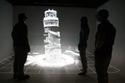
The scanner has previously been used in industries such as mining as well as in efforts to digitally preserve sites of cultural significance. The device has been used to create the first 3D map of the interior of the Leaning Tower of Pisa.
Michael Bosse, Robert Zlot, and Paul Flick from the CSIRO's Autonomous Systems Laboratory in Brisbane published a paper in 2012 outlining the design of the Zebedee. The paper, published in IEEE Transactions on Robotics (Vol. 28/No. 5, October 2012) explains that the Zebedee comprises "a 2D time-of-flight laser range scanner rigidly coupled to an inertial measurement unit and mounted on a spring."
"The mobility of the Zebedee sensor as a handheld device allows access to most environments accessible to humans, including rough, natural terrain and stairways," the paper states.
"Further to the experiments presented here, we have deployed the system in applications including large-scale assembly plants and indoor spaces, as well as mapped natural environments that would otherwise be inaccessible to standard 3D mapping systems."
A user just needs to walk through an area while the Zebedee's LiDAR scanner moves on the spring, capturing data that can later undergo processing to produce a 3D model.
The CSIRO technology was commercialised in 2012 through the UK-based 3D Laser Mapping, which sells the Zebedee-derived 'ZEB1' device as well as processing of data gathered with the device as a service.
Dr Jonathan Roberts from the CSIRO’s computational informatics division said that work on improving the Zebedee was continuing. "The latest research version contains a video camera to provide imagery on top of the 3D laser information," Roberts said in a statement.
"We’re very excited to see our home-grown, Eureka Prize-winning technology being used to help assess crime scenes — a new addition to what seems to be an ever-expanding number of applications. The 3D data visualisations that Zebedee creates provide a wealth of spatial information quickly and easily. It’s just a walk in the park!"