

Drones have proved hugely beneficial to ecologists in improving our understanding of animals in the wild.
Remotely piloted aircraft have been used to count African elephants, monitor rhino poaching operations, detect reptile nests, take censuses of penguins and assess the health of humpback whales.
“Such technologies have been vital in advancing our understanding of wildlife and answering fundamental questions, such as how many individuals are in a population and whether that population trajectory is increasing or decreasing,” says Jarrod Hodgson from Adelaide University's Environment Institute and School of Biological Sciences.
When it comes to unmanned aerial vehicles counting the number of individuals in a given population however, it is difficult to know how accurate drone assisted counts are.
"We needed to test the technology where we knew the correct answer. We couldn't use wild animals because we could never be sure of the real number of individuals present," Hodgson explained. "With so many animals across the world facing extinction, our need for accurate wildlife data has never been greater."
Together with his colleagues from Australian Antarctic Division, the University of Tasmania and Monash University, Hodgson came up with a cunning plan – involving a small, off-the-shelf quadcopter, computer vision techniques and around seven thousand ‘life-size plastic duck decoys’.
They called it ‘#EpicDuckChallenge’.

Count your chickens
On a sunny day last year, the researchers created 10 simulated greater crested tern breeding colonies on Port Willunga beach in South Australia.
They enlisted a team of professional ecologists each with prior experience observing and counting birds armed with tripod-mounted spotting scopes or binoculars and hand-held tally counters, to count each colony.
At the same time, a drone was flown at 30, 60, 90 and 120m above ground level to capture images of each colony.
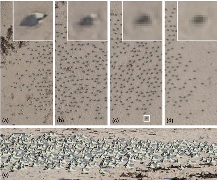
The drone captured images were then counted manually, by a team of citizen scientists, and also run through a semi-automated computer vision assisted counter.
On average, across all colonies, counts from RPA-derived imagery were between 43 per cent and 96 per cent more accurate than ground counts. People counting on location were found to significantly underestimate the number of plastic birds in the dummy colony.
"The drone approach won. We found it is more accurate and more precise to have people count birds from the drone imagery than to do it on location," Hodgson said.
What’s more the computer vision algorithms were found to be just as good (98 per cent similar) to manual counts using high quality imagery.
“By facilitating accurate census data, RPAs can provide ecologists with more confidence in population estimates from which management decisions can be made. Furthermore, the superior precision of counts from RPA images increases statistical power to detect population trends,” Hodgson says.
"Accurate monitoring can detect small changes in animal numbers. That is important because if we had to wait for a big shift in those numbers to notice the decline, it might be too late to conserve a threatened species."
The research was published this week in British Ecological Society journal Methods in Ecology and Evolution.
Wild ideas
Emerging technologies are being increasingly used by ecologists to better capture data 'in the wild'. Camera traps and acoustic recorders are now well established tools for determining which species are present at a site, and estimating populations.
Earlier this month, the Australian Wildlife Conservancy posted a job vacancy for a chief information officer who could identify "the potential associated with camera trap data collection and analysis, GPS telemetry, drones, remote sensing, artificial intelligence, thermal imagery, facial recognition, bioacoustics and more" to measure threatened species populations.
Underwater drones are also in use collecting animal data, with a number at work on the Great Barrier Reef. In 2016 the Australian Centre for Robotic Vision launched its prototype reef robot, COTSbot.
The bot was programmed to visually recognise and record populations of crown-of-thorns starfish (COTS), a reef-eating coral predator that can reach plague proportions. It also had an automated system that could inject the detected starfish with a solution to control their numbers.
The centre is currently testing five updated COTSbots called RangerBots.